It was high tide, blue sky and a perfect day, so as soon as we had set up it was on with the bathers for a swim before lunch. Jim then headed off with his rod in the hope of a good catch. He had chosen the far side of the bay as it looked like a little deeper water. I was reading my book, and looked out about half an hour later to discover no water there at all. We had forgotten about the big tides up here, and Jim was vainly trying to chase the water out. No fish for tea that night.
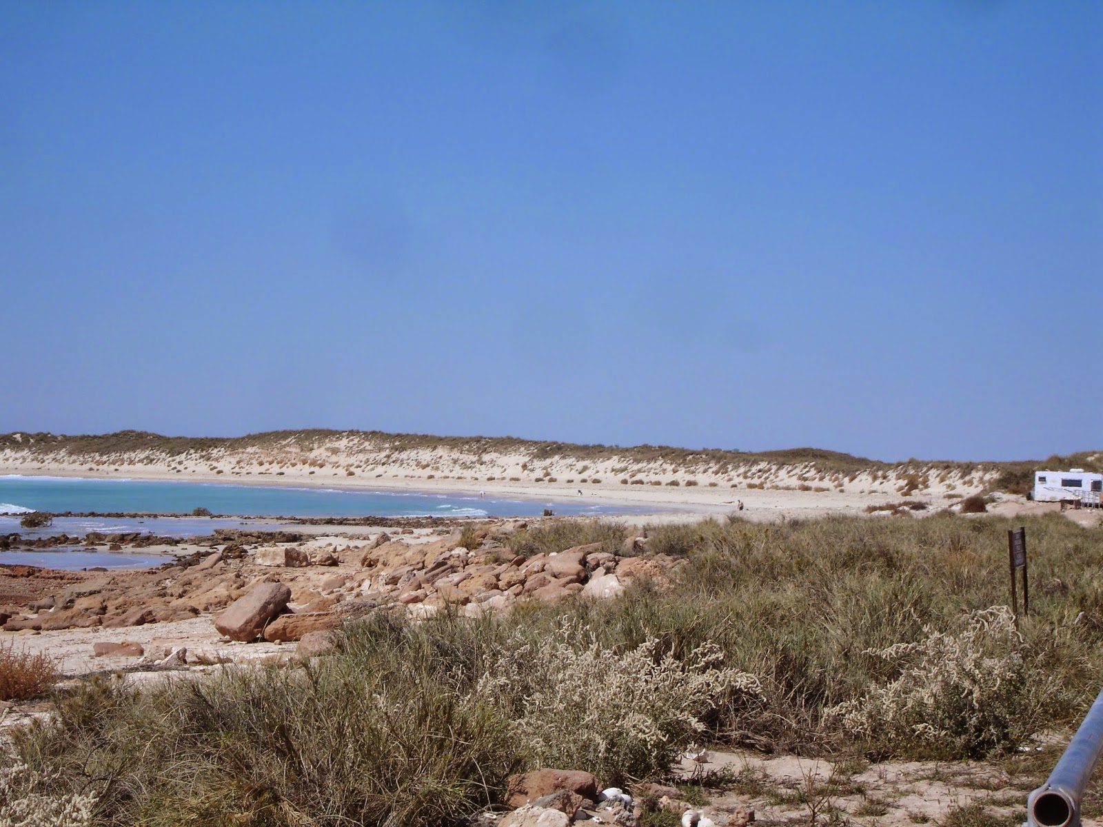
High tide

The same beach at low tide
We were looking forward to another swim at high tide the next day, but were disappointed to discover a very windy and overcast day, not at all conducive for a swim. Jim, not daunted, headed off with his rod again. He returned after about three hours with enough whiting and a bream for dinner. We walked the 1.5 k's up to the other camp and were surprised how many were in that area. We found the boat ramp interesting as with the tide variance, the only time a boat could be launched was when the tide was in. I don't know how they judge going out so that they can get back again.
The next morning over breakfast we did one of the things that are so good about this trip. We sat and discussed do we stay another night or do we head somewhere else. It's so nice to not be on a timetable. In the end we decided as the tide was right out and the next high tide probably nearly six hours away, it wasn't worth stopping as we couldn't swim or fish. So we packed up and made our way to Port Hedland, a distance of around 150 k's. Port Hedland didn't hold a lot of appeal for us and we had always decided one night was enough as we were really just looking at restocking the pantry. Being such a busy industrial area, the caravan parks are quite expensive, over $50 a night for sites that are very small. One of the parks we gathered would struggle to fit our van in, and others with similar sizes had had to pay for two sites. So it was an easy decision to head to the golf club that has basic sites, no power or water, but half the price.
Port Hedland was a very busy place with so much infrastructure happening. Even the road we came in on didn't show on our gps or phone. There was road and building construction going on everywhere we looked. We went into the city centre and found it very different to others. It reminded me a little of Mt Isa, with all the industrial happenings right in the city centre. For Port Hedland this meant the shipping area right in the centre of town. We didn't get to see any off the huge cargo ships heading out, but the information centre had a list of what was departing. We could see six heading to China and one to Japan, filled with hundreds of thousands of tons of iron ore.

In the centre of town, Port Hedland
What we did see as we were heading back was one of the iron ore trains. We arrived at the photo point just before the train so excellent timing for us. It had to have been about 3 kilometres long. Would hate to meet that at a rail crossing.

Iron ore train

that just kept on coming
We had a very big spend up at the supermarket, after nearly two weeks since the last shop. The next morning we headed back to refuel and grab a few last minute items. We were a little later getting away than normal, but weren't worried as our destination wasn't a time issue. We were heading to Karajini, but were going to stop at a rest area about 60 k's from the park so we could arrive at Karajini in the morning. We knew it is peak time and if you arrive too late, you can end up in the overflow area, something we didn't want to happen
The road from Port Hedland was like nothing else we have been on. It is the main road to Newman, a huge mining area, plus there are many mines off the road as well. To say the road is busy would be an understatement. It was just filled with huge road trains going in either direction. They travel at 90 k's an hour. Unfortunately a little in front of us was a big cattle road train, and it kept fluctuating its speed which was pretty frustrating as the road was too busy to attempt to get past it. Eventually we stopped for lunch, and our timing was perfect coming out as there were no road trains in front or behind, so we sat on 90 knowing they wouldn't catch us, or us catch them.
Our stop for the night was the Albert Tognolini Rest Area and Lookout. Although having no facilities, this is a very popular stopover. It's a huge area, and we got a lovely spot overlooking the ridge to enjoy the sunset. We managed to find some wood to have a nice campfire for the evening. It has wonderful scenery for a free rest area.

Road through the gap looking out from the lookout

Looking back at our campsite on the ridge

Sunset

Early morning light on the hills
We left around 8 the next morning for Karijini. At the turnoff we stopped to check emails. We had lost phone reception just before the rest area, but here, right in the middle of absolutely nothing, the local council has put in a wifi hotspot. There are a number of these across the shire and there had also been one at Cape Keraudren.
Arriving at Karijini, we lined up to be allocated a site by the camp hosts. This is a great idea that Western Australia has with their national parks in peak times. Camp hosts get free sites and a number of other incentives and in return they effectively manage the camp sites. This is a busy place and it looked like two couples were here. One of them told us they had another month here and then were going for a month to the Ningaloo area. They loved what they were doing.
We were allocated a really lovely big site, but within about an hour we could see it wasn't going to suit us. Most people would be very happy with the lovely shady site but unfortunately our solar panels had not worked at all when it should have been peak time. Walking back to the office area, we noticed two sites from us was still empty, and what's more completely in the sun. They were happy enough to change us over, and we did a quick move over, being able to carry somethings rather than pack up.
After lunch it was time to start seeing why Karijini is so popular. We headed down the steep path to Fortescue Falls but could see that although spectacular, it was quite shaded and likely to be very cold. We continued on to Fern Pool. What a beautiful place and it wasn't long before we were in the water and swimming to the waterfall. The water coming over was amazingly warm.

Jim under the waterfall at Fern Pool
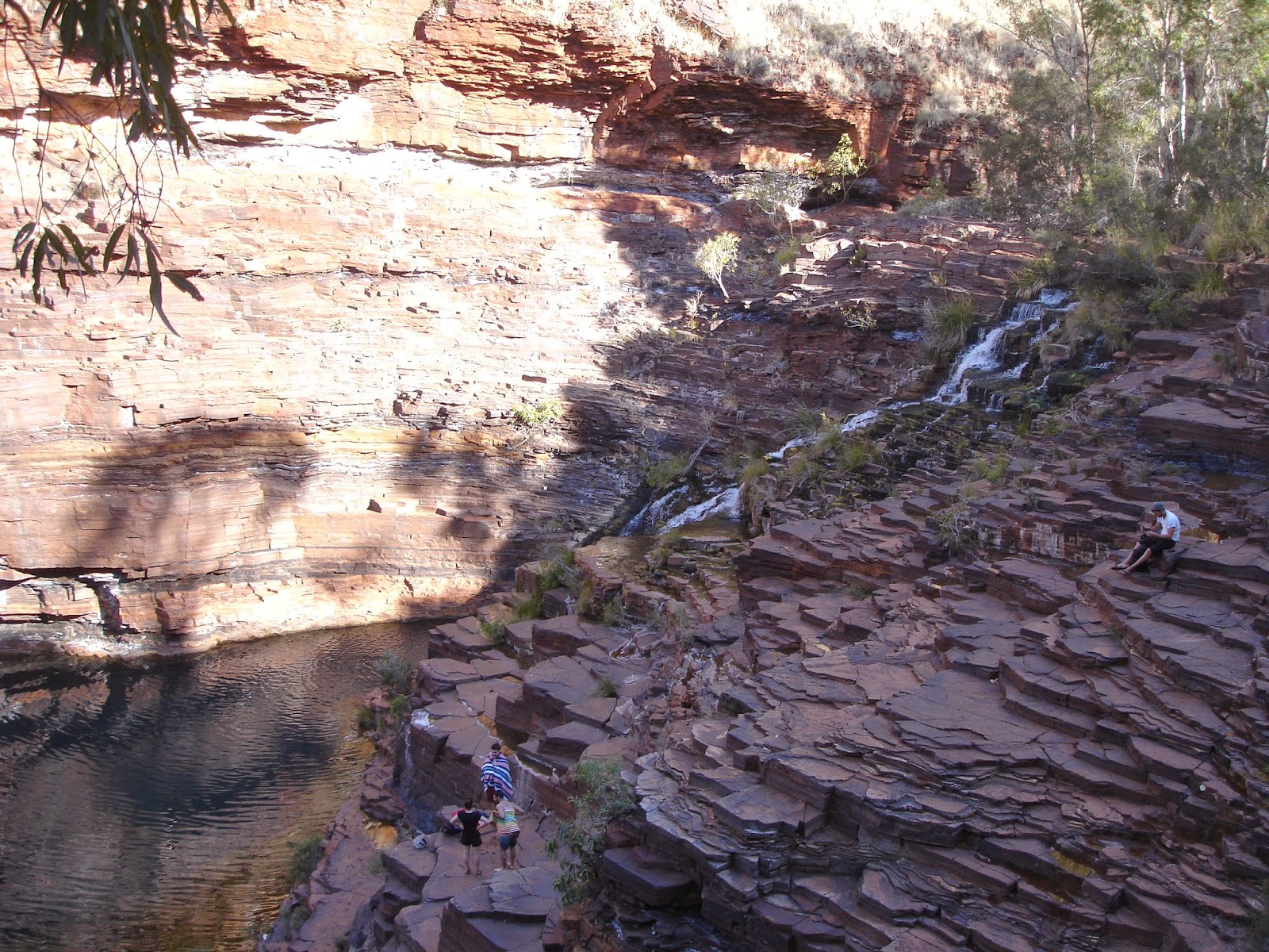
Fortescue Falls. We had to climb down the terraced rocks to do the bottom gorge walk

Fortescue Falls from the rim
After returning, we decided to get ourselves limbered up for the big walk in the morning, and did a walk around areas of the campground. It is a big place, set out in circuits. Most sites are well spaced from others and the toilets are dotted throughout the campground. Each circuit also has a BBQ area as fires are not allowed. It is easy to see why it is rated so highly.
Saturday morning, we were off on our walk by 8.30. The other side of our circuit, the Euro circuit, has a track that links to the Circuit Pool lookout. We took this and then picked up the rim walk. The end of that walk brought us to to steep climb down to the Fortescue Falls. This time we continued right down to the bottom, using the trellaced rock face as steps. From here we took the gorge floor walk right back to the Circular Pool. There were a few people already here, some attempting a quick dip in the very cold water. I convinced Jim he didn't really need to try the pool out, and we then headed out to they very, very steep climb up to the lookout. One of the camphosts the day before had said that it was difficult with big uneven steps and was easier to go up than down. We aren't too sure if we agree with him, but we eventually made it to the top and picked up the track back to the campground. It was then 11.30, so three hours from when we had headed out. A good morning's exercise.

Circular Pool from above

and from below
After lunch we drove out to the visitor centre as we hadn't bothered stopping there on our way in. It was a very unique building, blending well with the landscape with lots of interesting history both aboriginal and white of the area. But what it didn't have in any form was information on what there was to see and do in the park. I found this quite surprising. Not even a photo of any of the gorges.
As there is quite a lot to see on the western side of the park, we opted to head to Kalamina Gorge, about 25 k's from the visitor centre rather than attempt too much the next day. This is supposed to be one of the easier walks in the park, and we completed this one in about an hour and a half. It was quite interesting with lots of little pools and waterfalls, but the final destination was lacking some of the wow facture we were expecting.

Kalamina Gorge

The ledges we had to make our way along
Sunday morning we were again off by 8.30, this time to the western area of the park. Our first stop was Weano Gorge and the nice walk along its bottom. We did the upper gorge loop and were looking to do the lower which included Handrail Pool, but after only a few metres we could see there was no way through except through the water. We waited to see what would happen to those in front of us. A man with a mission took his shoes off and waded through, managing to wet most of the shorts he was wearing When he had crossed one side, he went behind a rock and changed into his bathers. Unfortunately this didn't help him as the next step out he took had him slipping and going right under, backpack and all. The next was a young girl who didn't make it to the first point without slipping as well and dunking the shoes she was holding in her hand. We soon decided we didn't really need to see that gorge after all.
We took the steps back to the top and walked over to the lookouts. Now these were seriously impressive. They are where four separate gorges meet and it is certainly quite a sight.

Lookout where four gorges meet
As we were walking back to the capark, we spotted a walkway to Hancock Gorge. This was rated higher than any of the other walks we had done, but we decided to give it a go. It was very much a straight vertical descent, including some ladders. Once at the bottom it was beautiful and quite different to the other gorges particularly in colour. It was orange where the others were red. It looked like it had been painted on. After a bit of rock hopping and ledge holding, we came to a body of water with again no way through but in. Jim changed into his bathers and waded across. It was pretty obvious to me that I was going to get quite wet, so I left him to explore a little further. He gave up when the gorge narrowed and there was little space to walk along the ledge with a backpack on. So back up the steep slope to the top. We think we must be getting a lot fitter with all this climbing.

Stairs to access Hancock Gorge


Jim wading through and what he found on the other side

Knox Gorge Lookout


Joffre Gorge Lookout. The marks defining the path can be just seen on the rocks on the left
It was still early afternoon, so this still gave us time to get back to the camp and have another swim in Fern Pool.
I had originally paid for four nights, but by Sunday night we decided we had really covered all we needed to and it was probably better to cut our losses and leave a day early. The next destination was the town of Tom Price where we sat through our video to gain our permit to drive on the Rio Tinto Access Road. This is over 200 k's of dirt road, so we hope we don't regret the decision, but it will save us 200 - 300 extra kilometres.
After some supermarket shopping we unhitched the van at the bottom of Mt. Nameless and took the 4wd road to the top. Some fantastic 360 degrees views are to be had up there.

Views of the mine and works from Mount Nameless Lookout


View of Tom Price township
We drove out ten kilometres to a roadside rest area for the night, being up and gone early for our 8.30 am mine tour. The bus driver was excellent and we learnt so much about the miming and processing of the iron ore.


Some of the huge processing area

The iron ore falling here has come 20 kilometres via conveyor belt from one of the newer mines. The conveyor system cost 1 billion dollars.
Once back from the tour, we refilled the water tanks and headed out with some trepidation on the private mine railway access road that we got the permit for the day before. Much to our surprise, the road was in very good condition and traffic was minimal. We passed 4 or 5 of the 2.5 kilometre trains that run next to the road. We waved as we went past, and every driver gave us a big toot back. We had heard that morning that the trip takes them 5.5 hours, so I guess they get pretty bored.
We had trouble finding somewhere to pull over to stop for lunch, but finally found a flat area we could get off the road. As I walked to the van, I could hear water running. We had had a few drops of rain, but not enough for that amount of water. I soon discovered our water tanks running onto the ground. It didn't take Jim long to discover that the rocks hammering underneath had sheared off the release tap from the tanks. A makeshift plug saved the little that was left. We opted what to do but decided to continue with our original plan of stopping at Millstream Chichester National Park, which was only around 30 kilometres away.
We weren't too sure how worthwhile the stop was going to be, so were quite surprised to find it was a very pleasant place to stop. The original homestead is now the visitor centre and there was a delightful walk around what used to be the extensive gardens where many date palms had been planted in 1914.

The beautiful old homestead, now the visitor's centre

Massive old wood stove in the shearer's quarters

This plant was nearly a metre under the water and such a vivid colour

Sturts Desert Pea scattered around the homestead
One of the other interesting things about the park is that it has a massive aquifer that supplies the towns of Karratha and Dampier. So one thing there wasn't a shortage of was water, which was a good thing for us.
No comments:
Post a Comment